Bildquelle/n:
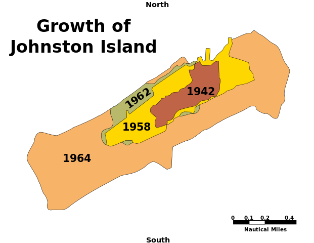
- Karte: Vergrößerung der Johnston-Insel von 1942 bis 1964: User:Indolences, Wikimedia Commons | Public Domain Mark 1.0
Abhängige und Übersee-Gebiete der Erde
Digitaler Almanach über Geografie, Politik, Vexillologie, Heraldik, Linguistik u.v.m.
Fläche: 2,68 km² – bestehend aus: Johnston-Insel (Johnston Island) 2,41 km² mit Sand-Insel (Sand Island) 0,09 km² und den künstlich aufgeschütteten Inseln Akau (North Island) 0,10 km² und Hikina (East Island) 0,07 km² – n. and. Ang. 2,6 km² bzw. 2,8 km² – EEZ: 442.635 km²
Bildquelle/n:
Kommentare sind geschlossen.
Australien
Ashmore- und Cartier-Inseln ■ Australische Antarktis-Territorium ■ Heard- und McDonald-Inseln ■ Jervis-Bucht-Territorium ■ Kokos-(Keeling-)Inseln 🇨🇨 ■ Korallenmeer-Inseln ■ Norfolk-Insel 🇳🇫 ■ Weihnachts-Insel 🇨🇽
Dänemark
Frankreich
Clipperton Atoll ■ Französisch-Guyana 🇬🇫 ■ Französisch-Polynesien 🇵🇫 ■ Französische Süd- und Antarktisgebiete 🇹🇫 ■ Französische Süd- und Antarktisgebiete: Adelieland ■ Französische Süd- und Antarktisgebiete: Crozet-Inseln ■ Französische Süd- und Antarktisgebiete: Kerguelen ■ Französische Süd- und Antarktisgebiete: Saint-Paul und Amsterdam ■ Französische Süd- und Antarktisgebiete: „Verstreute Inseln“ ■ Guadeloupe 🇬🇵 ■ Martinique 🇲🇶 ■ Mayotte 🇾🇹 ■ Neukaledonien 🇳🇨 ■ Réunion 🇷🇪 ■ Saint-Barthélemy 🇧🇱 ■ Saint-Martin ■ Saint-Pierre und Miquelon 🇵🇲 ■ Wallis und Futuna 🇼🇫
Neuseeland
Cook-Inseln 🇨🇰 ■ Cook-Inseln: Palmerston Atoll ■ Niue 🇳🇺 ■ Ross-Dependenz ■ Tokelau 🇹🇰
Niederlande
Aruba 🇦🇼 ■ Curaçao 🇨🇼 ■ Sint Maarten 🇸🇽 ■ BES-Inseln bzw. Karibische Niederlande ■ BES-Inseln bzw. Karibische Niederlande: Bonaire 🇧🇶 ■ BES-Inseln bzw. Karibische Niederlande: Saba ■ BES-Inseln bzw. Karibische Niederlande: Sint Eustatius
Norwegen
Bouvet-Insel ■ Jan Mayen ■ Königin Maud-Land ■ Peter-I.-Insel ■ Svalbard
Vereinigtes Königreich
Anguilla 🇦🇮 ■ Bermuda 🇧🇲 ■ Britische Jungfern-Inseln 🇻🇬 ■ Britisches Antarktis-Territorium ■ Britisches Territorium im Indischen Ozean 🇮🇴 ■ Britisches Territorium im Indischen Ozean: „Chagossianer“ ■ Cayman-Inseln 🇰🇾 ■ Falkland-Inseln 🇫🇰 ■ Gibraltar 🇬🇮 ■ Guernsey 🇬🇬 ■ Guernsey: Alderney ■ Guernsey: Sark ■ Insel Man 🇮🇲 ■ Jersey 🇯🇪 ■ Montserrat 🇲🇸 ■ Pitcairn-Inseln 🇵🇳 ■ Sankt Helena, Ascension und Tristan da Cunha ■ Sankt Helena, Ascension und Tristan da Cunha: Ascension 🇦🇨 ■ Sankt Helena, Ascension und Tristan da Cunha: Gough-Insel ■ Sankt Helena, Ascension und Tristan da Cunha: Sankt Helena 🇸🇭 ■ Sankt Helena, Ascension und Tristan da Cunha: Tristan da Cunha 🇹🇦 ■ Souveräne Militärbasen Akrotiri und Dhekelia ■ Südgeorgien und Südsandwich-Inseln 🇬🇸 ■ Turks- und Caicos-Inseln 🇹🇨
Vereinigte Staaten
Amerikanisch-Samoa 🇦🇸 ■ Amerikanisch-Samoa: Swains ■ Amerikanische Jungfern-Inseln 🇻🇮 ■ Baker-Insel ■ Guam 🇬🇺 ■ Guantánamo-Bucht ■ Howland-Insel ■ Jarvis-Insel ■ Johnston Atoll ■ Kingman-Riff ■ Midway Atoll ■ Navassa-Insel ■ Nördliche Marianen 🇲🇵■ Palmyra Atoll ■ Puerto Rico 🇵🇷 ■ Wake Atoll
Amerikanisch-Samoa 🇦🇸 ■ Amerikanisch-Samoa: Swains ■ Amerikanische Jungfern-Inseln 🇻🇮 ■ Anguilla 🇦🇮 ■ Aruba 🇦🇼 ■ Ashmore- und Cartier-Inseln ■ Australische Antarktis-Territorium ■ Baker-Insel ■ Bermuda 🇧🇲 ■ Bouvet-Insel ■ Britische Jungfern-Inseln 🇻🇬 ■ Britisches Antarktis-Territorium ■ Britisches Territorium im Indischen Ozean 🇮🇴 ■ Britisches Territorium im Indischen Ozean: „Chagossianer“ ■ Cayman-Inseln 🇰🇾 ■ Clipperton Atoll ■ Cook-Inseln 🇨🇰 ■ Cook-Inseln: Palmerston Atoll ■ Curaçao 🇨🇼 ■ Färöer 🇫🇴 ■ Falkland-Inseln 🇫🇰 ■ Französisch-Guyana 🇬🇫 ■ Französisch-Polynesien 🇵🇫 ■ Französische Süd- und Antarktisgebiete 🇹🇫 ■ Französische Süd- und Antarktisgebiete: Adelieland ■ Französische Süd- und Antarktisgebiete: Crozet-Inseln ■ Französische Süd- und Antarktisgebiete: Kerguelen ■ Französische Süd- und Antarktisgebiete: Saint-Paul und Amsterdam ■ Französische Süd- und Antarktisgebiete: „Verstreute Inseln“ ■ Gibraltar 🇬🇮 ■ Grönland 🇬🇱 ■ Guadeloupe 🇬🇵 ■ Guam 🇬🇺 ■ Guantánamo-Bucht ■ Guernsey 🇬🇬 ■ Guernsey: Alderney ■ Guernsey: Sark ■ Heard- und McDonald-Inseln ■ Howland-Insel ■ Insel Man 🇮🇲 ■ Jan Mayen ■ Jarvis-Insel ■ Jersey 🇯🇪 ■ Jervis-Bucht-Territorium ■ Johnston Atoll ■ Kingman-Riff ■ Königin Maud-Land ■ Kokos-(Keeling-)Inseln 🇨🇨 ■ Korallenmeer-Inseln ■ Martinique 🇲🇶 ■ Mayotte 🇾🇹 ■ Midway Atoll ■ Montserrat 🇲🇸 ■ Navassa-Insel ■ Neukaledonien 🇳🇨 ■ Niue 🇳🇺 ■ Nördliche Marianen 🇲🇵 ■ Norfolk-Insel 🇳🇫 ■ Palmyra Atoll ■ Peter-I.-Insel ■ Pitcairn-Inseln 🇵🇳 ■ Puerto Rico 🇵🇷 ■ Réunion 🇷🇪 ■ Ross-Dependenz ■ Saint-Barthélemy 🇧🇱 ■ Saint-Martin ■ Saint-Pierre und Miquelon 🇵🇲 ■ Sankt Helena, Ascension und Tristan da Cunha ■ Sankt Helena, Ascension und Tristan da Cunha: Ascension 🇦🇨 ■ Sankt Helena, Ascension und Tristan da Cunha: Gough-Insel ■ Sankt Helena, Ascension und Tristan da Cunha: Sankt Helena 🇸🇭 ■ Sankt Helena, Ascension und Tristan da Cunha: Tristan da Cunha 🇹🇦 ■ Sint Maarten 🇸🇽 ■ Souveräne Militärbasen Akrotiri und Dhekelia ■ Südgeorgien und Südsandwich-Inseln 🇬🇸 ■ Svalbard ■ Tokelau 🇹🇰 ■ Turks- und Caicos-Inseln 🇹🇨 ■ Wake Atoll ■ Wallis und Futuna 🇼🇫 ■ Weihnachts-Insel 🇨🇽 ■ BES-Inseln bzw. Karibische Niederlande ■ BES-Inseln bzw. Karibische Niederlande: Bonaire 🇧🇶 ■ BES-Inseln bzw. Karibische Niederlande: Saba ■ BES-Inseln bzw. Karibische Niederlande: Sint Eustatius
Neueste Kommentare